Isle of Man TT Course (OpenStreetMap)
Click or tap the map to enlarge it.
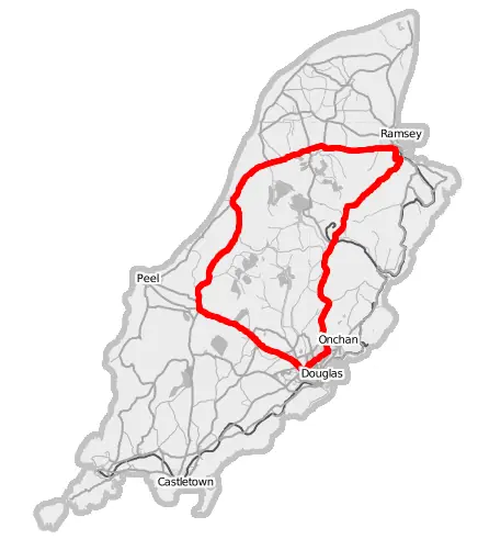
This map, made from OpenStreetMap data, shows the Snaefell Mountain Course on the Isle of Man, the 37.73-mile (60.72 km) circuit of public roads used for the Isle of Man TT motorcycle races. The map labels Douglas, Onchan, Peel and Ramsey.
The road course is closed to normal traffic during race fortnight, held each year at the end of May and early June.
The course on the map
The route starts in Douglas, drops down Bray Hill and heads north-west through Ballacraine and Glen Helen, then runs north through Kirk Michael and Ballaugh to Ramsey, before crossing the island's central mountain and descending through Creg-ny-Baa and Governor's Bridge back to Douglas. The Mountain section reaches around 400 metres above sea level.
The TT began in 1907 and the Mountain Course was first used in 1911. Several variants of the layout were used before the present one was adopted.
Speed and risk
The fastest lap on the course exceeds 135 miles per hour in average speed, with Peter Hickman setting a record in 2018. The event is also notorious for its safety record, and the number of fatalities over its history has caused repeated debate. The Isle of Man is a self-governing Crown dependency, which allows it to close public roads for racing.
Race week
TT fortnight is split into practice sessions and races for several classes, including Superbike, Supersport, Superstock, Sidecar and the Senior TT. Unlike most races, riders do not start together: they leave the line one by one at ten-second intervals, and the winner is the rider with the fastest overall time. The Manx Grand Prix in August uses the same roads. During practice and racing, the roads are closed and residents plan their travel around the timetable.
Key facts
| Fact | Detail |
|---|---|
| Lap length | 37.73 miles (60.72 km) |
| First TT | 1907 |
| Mountain Course first used | 1911 |
| Start and finish | Douglas |
| Map data | OpenStreetMap contributors |
Questions about this map
Where is the Isle of Man?
In the Irish Sea, between Great Britain and Ireland.
When is the TT?
Late May to early June each year.
Are the roads public?
Yes, they are normal public roads that are closed for racing.