Kaliningrad Map
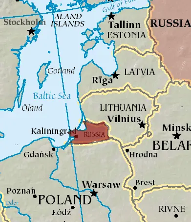
Click or tap the map to enlarge it.
Kaliningrad Map – Exploring the Enigmatic Northwestern Corner of Russia
Key Takeaways
- Kaliningrad is a unique exclave located between Poland and Lithuania.
- The Kaliningrad Map reveals the diverse history, culture, and natural beauty of this region.
- Explore the fortified city of Kaliningrad, picturesque coastal towns, and stunning natural landscapes.
- Discover historical landmarks, museums, and vibrant local cuisine.
- The map showcases the rich history of the Teutonic Knights, Hanseatic League, and Soviet era.
History
Kaliningrad, also known as Königsberg, has a fascinating historical background. The region was once home to the Prussian people and was ruled by the Teutonic Knights in the Middle Ages. With its strategic location on the Baltic Sea, the area experienced significant cultural and political developments over the centuries.
The seventeenth century marked the rise of the Hanseatic League, a powerful trading confederation that greatly influenced the region’s prosperity. Königsberg grew as an important center for commerce, education, and culture.
In the aftermath of World War II, the region was annexed by the Soviet Union and heavily destroyed. Königsberg was renamed Kaliningrad, and the German population was expelled, with Soviet settlers taking their place. Today, Kaliningrad serves as an important Russian enclave and is a hub of economic and cultural activity.
Unique Insights
The Kaliningrad Map provides valuable insights into the region’s distinctive characteristics:
- Exclave Status: Kaliningrad is an exclave, separated from mainland Russia by other countries. This geographical uniqueness gives the territory its intriguing identity.
- Fascinating Architecture: The map highlights architectural landmarks, such as the Königsberg Castle ruins, and the grand Cathedral of Christ the Savior. These structures offer a glimpse into the city’s rich history.
- Beautiful Coastal Areas: With its access to the Baltic Sea, the Kaliningrad Map showcases stunning coastal towns like Svetlogorsk and Zelenogradsk. Visitors can enjoy sandy beaches, picturesque promenades, and fresh seafood.
- Natural Wonders: Kaliningrad is home to numerous natural attractions, including the Curonian Spit, a UNESCO World Heritage Site known for its unique sand dunes and diverse ecosystems.
- Diverse Cultural Heritage: The region’s history and influences from various cultures have resulted in a rich cultural tapestry. The map points out museums, art galleries, and theaters that showcase Kaliningrad’s artistic heritage.
Table of Relevant Facts
| Year | Event |
|---|---|
| 1255 | Teutonic Knights establish Königsberg |
| 1724 | Königsberg Cathedral construction completed |
| 1818 | Königsberg University founded |
| 1945 | Annexation of Königsberg by the Soviet Union |
| 1946 | Königsberg renamed Kaliningrad |
FAQ
-
What is Kaliningrad?
Kaliningrad is an exclave of Russia located between Poland and Lithuania.
-
What can I explore in Kaliningrad?
You can explore the fortified city of Kaliningrad, coastal towns, historical landmarks, museums, and stunning natural landscapes.
-
What is the history of Kaliningrad?
Kaliningrad has a diverse history, with influences from the Teutonic Knights, Hanseatic League, and the Soviet era.
-
What are the main attractions in Kaliningrad?
Main attractions include Königsberg Castle ruins, the Cathedral of Christ the Savior, Curonian Spit, and the vibrant local cuisine.
-
Is Kaliningrad easily accessible?
While Kaliningrad is an exclave, it is well connected by air, rail, and road links.
-
What is the best time to visit Kaliningrad?
The summer months are ideal for visiting Kaliningrad due to pleasant weather and festivals.
-
Is it possible to visit other European countries from Kaliningrad?
Yes, Kaliningrad’s location between Poland and Lithuania allows for easy exploration of neighboring countries.