Pearl Harbor Bombings Map
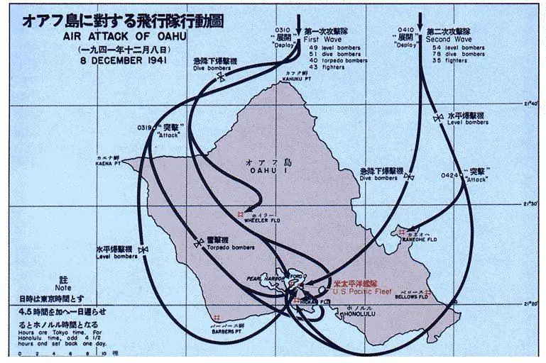
Click or tap the map to enlarge it.
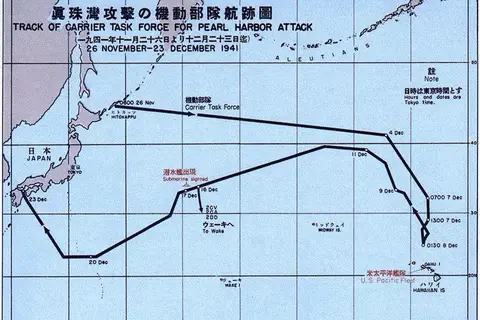
This Japanese-language chart shows the routes taken by Imperial Japanese Navy aircraft in the attack on Pearl Harbor, on the island of Oahu in Hawaii. It is dated 8 December 1941 because Japan lies on the other side of the International Date Line from Hawaii.
The surprise attack began shortly before 8 a.m. local time on Sunday 7 December 1941 and lasted about two hours.
How the attack was organised
Six Japanese aircraft carriers sailed secretly across the north Pacific and launched 353 aircraft in two waves. The first wave arrived over Oahu at about 7:48 a.m. and the second followed roughly an hour later. The curved lines on a chart like this show the approach to the island and the sweeps over Pearl Harbor and the nearby airfields.
American losses were severe: 2,403 Americans were killed, of whom 68 were civilians, and eight battleships were damaged, four of them sunk. The USS Arizona alone lost 1,177 crew.
What the attack did not achieve
The three Pacific Fleet aircraft carriers were at sea and escaped, and Japan did not strike the fuel tanks or repair yards. Most of the damaged ships, apart from the Arizona and the capsized Oklahoma, were later repaired. The United States declared war on Japan the next day, 8 December, and Germany and Italy declared war on the United States on 11 December. The Arizona Memorial now marks the site.
Key facts
| Fact | Detail |
|---|---|
| Date | 7 December 1941 (8 December in Japan) |
| Aircraft launched | 353 in two waves, from six carriers |
| US dead | 2,403, including 68 civilians |
| Battleships sunk | Four: Arizona, Oklahoma, West Virginia, California |
| US declaration of war on Japan | 8 December 1941 |
Questions about this map
Why is the chart dated 8 December?
It was made in Japan, where the date was one day ahead of Hawaii.
Where is Pearl Harbor?
On the south coast of Oahu, near Honolulu, in Hawaii.
Were the aircraft carriers hit?
No. The Pacific Fleet's carriers were not in port that morning.