Religion in Europe, 1950: Map
Click or tap the map to enlarge it.
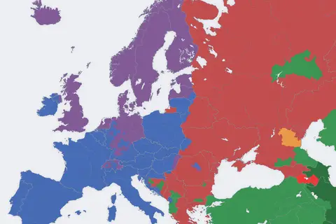
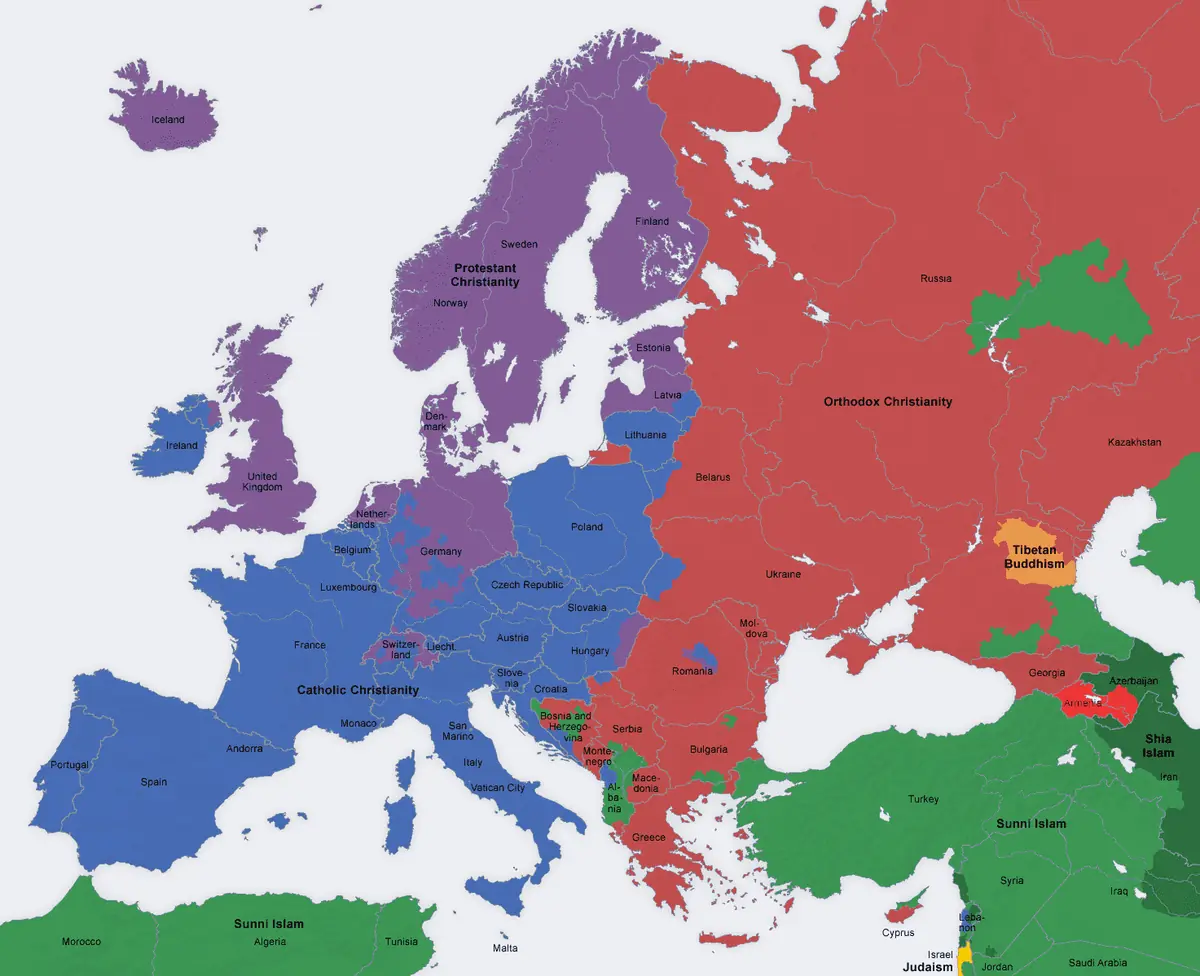
This map shows the dominant religious tradition across Europe around 1950, with colours separating Catholic, Protestant, Orthodox and Muslim areas, and smaller patches for Judaism in Israel and Tibetan Buddhism in Kalmykia.
The mid-twentieth century is a useful moment to examine because the Second World War had redrawn borders and the Iron Curtain had split the continent into East and West.
The old religious fault lines
The pattern on the map reflects centuries of history. Catholic Christianity dominated southern and western Europe and Poland, Protestantism was strongest in the north, including Scandinavia and parts of Germany and Switzerland, and Orthodoxy prevailed in Russia, Romania, Bulgaria, Serbia and Greece. Albania, Bosnia and parts of the Balkans had Muslim majorities or large Muslim communities, as did Turkey.
Many countries were mixed. Germany, for example, was divided between a mainly Protestant north and a mainly Catholic south, and the map shows that regional split. Elsewhere a single colour hides sizeable minorities.
Religion in the Eastern bloc
After 1945 communist governments in Eastern Europe restricted religious institutions to varying degrees. The Soviet Union, Albania and others pursued active campaigns against organised religion, while Poland's Catholic Church kept considerable influence. A 1950 map therefore shows the starting point for decades of change, including later secularisation across the continent.
Key facts
| Tradition | Typical regions |
|---|---|
| Catholic | France, Italy, Spain, Portugal, Poland, Ireland, Austria |
| Protestant | Scandinavia, the United Kingdom, northern Germany, the Netherlands (mixed) |
| Orthodox | Russia, Romania, Bulgaria, Serbia, Greece |
| Muslim | Albania, Bosnia, Turkey (partly in Europe) |
Questions about this map
Why show only the main tradition?
It simplifies a complex picture, which is a limitation of any map of this kind.
What changed after 1950?
Secularisation, migration and the end of communism in 1989 to 1991 altered the picture.
Is the map a census?
No, it is a generalisation of the main tradition in each country.