Greater London Map with Suburban Towns
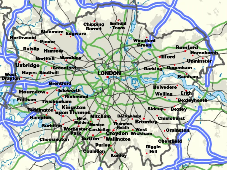
Click or tap the map to enlarge it.
Greater London Map With Suburban Towns
Key Takeaways
- Greater London is composed of the City of London and 32 distinct boroughs.
- The map provides detailed information about the suburban towns within Greater London.
- It highlights key landmarks, attractions, and major road networks in the area.
- Exploring the map can help residents and tourists navigate and familiarize themselves with Greater London.
- The suburban towns surrounding London are diverse in terms of culture, history, and attractions.
History
Greater London, also known as London or London County, is a county located in Southeast England. With origins dating back to Roman times, London has a rich history that spans over two millennia.
London became the capital of England in the 12th century and evolved into a major city and economic hub. Over the centuries, it grew rapidly, absorbing neighboring towns and villages. In 1965, the county of Greater London was created, consisting of the City of London and 32 London boroughs. The map of Greater London with suburban towns provides an overview of this vibrant and diverse region.
Unique Insights
- The City of London, often referred to as the “Square Mile,” is the historic and financial heart of London.
- The River Thames flows through the city, offering scenic views and playing a crucial role in the region’s trade and transportation.
- Each borough within Greater London has its own distinct character, with unique landmarks and cultural attractions.
- The map showcases famous landmarks such as the Tower of London, Buckingham Palace, and the Houses of Parliament.
- Visitors to Greater London can explore a variety of museums, art galleries, theaters, and world-class shopping districts.
- Green spaces and parks, including Hyde Park and Richmond Park, offer a refreshing escape from the bustling city life.
- Major road networks like the M25 encircle Greater London, connecting it with other parts of the United Kingdom.
Relevant Facts
| Date | Event |
|---|---|
| 43 AD | The Romans establish Londinium (the precursor to London) as a trading port. |
| 1066 | William the Conqueror becomes the King of England, leading to significant development in London. |
| 1851 | The Great Exhibition takes place at the Crystal Palace in Hyde Park, showcasing industrial and cultural achievements. |
| 1940-1941 | London experiences heavy bombing during World War II. |
| 1965 | The creation of Greater London, comprising the City of London and 32 boroughs. |
FAQ
1. What is the significance of the City of London?
The City of London, often referred to as the Square Mile, is the historic and financial center of London. It is home to many important financial institutions, including the Bank of England and the London Stock Exchange.
2. How many boroughs are there in Greater London?
Greater London is composed of 32 distinct boroughs, each with its own local government and unique characteristics.
3. Can tourists visit the suburban towns mentioned on the map?
Absolutely! The suburban towns within Greater London offer a wealth of attractions and historical sites for tourists to explore.
4. What are some must-visit landmarks in Greater London?
Some popular landmarks include the Tower of London, Buckingham Palace, the Houses of Parliament, and the British Museum.
5. Are there any green areas in Greater London?
Yes, there are numerous parks and green spaces within Greater London, such as Hyde Park, Regent’s Park, and Richmond Park.
6. How is Greater London connected with other parts of the United Kingdom?
Greater London is well-connected by major road networks like the M25, which encircles the region, and various railway lines.
7. Can I find world-class shopping districts in Greater London?
Absolutely! Greater London is renowned for its world-class shopping districts, including Oxford Street, Bond Street, and Covent Garden.