Jutland Peninsula Map
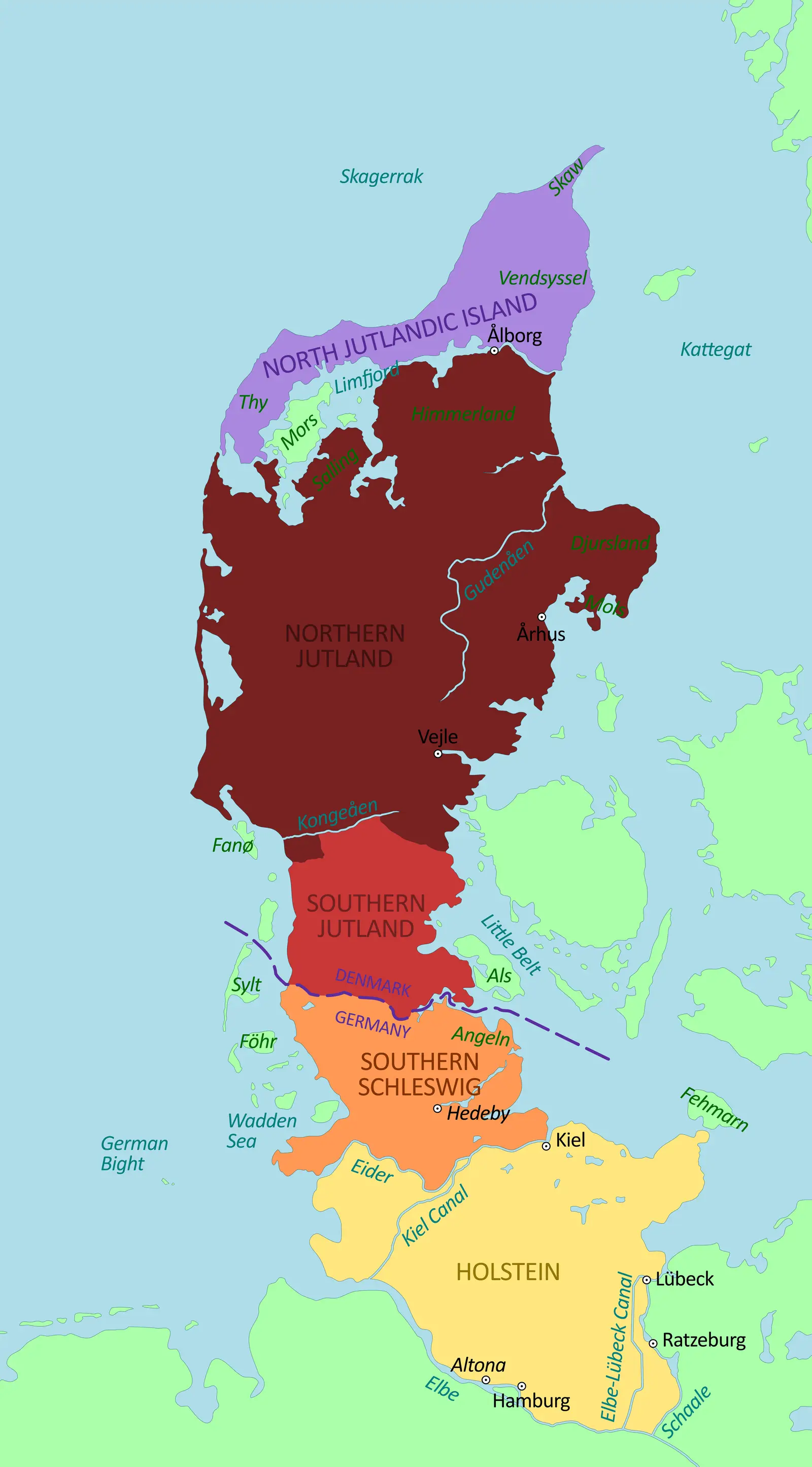
Click or tap the map to enlarge it.
Jutland Peninsula Map
Key Takeaways
- The Jutland Peninsula is located in Northern Europe.
- It is predominantly part of Denmark, with a smaller portion belonging to Germany.
- The peninsula is known for its unique geography and rich history.
- Its strategic location has played a significant role in trade and transportation throughout centuries.
- Exploring the Jutland Peninsula offers breathtaking natural landscapes and cultural experiences.
History
The Jutland Peninsula has a fascinating history that dates back thousands of years. It was originally inhabited by various Germanic tribes, including the Angles and the Jutes. During the Viking Age, the peninsula became a significant center of Norse culture and maritime trade.
In the medieval period, the region saw the rise of several powerful kingdoms, including Denmark. The Jutland Peninsula’s strategic location and its access to the North Sea and the Baltic Sea made it a critical hub for maritime commerce.
Over the centuries, the Jutland Peninsula experienced conflicts, wars, and changing borders. The region has been a point of contention between Denmark and Germany. Today, the northern part of the peninsula belongs to Denmark, while the southern region is part of Germany.
Unique Insights
1. Diverse Landscapes: The Jutland Peninsula offers a remarkable variety of landscapes, including rolling hills, coastal dunes, fjords, and forests. These diverse natural features make it an attractive destination for outdoor enthusiasts and nature lovers.
2. UNESCO World Heritage Sites: The peninsula is home to several UNESCO World Heritage Sites, such as the Wadden Sea, which is known for its unique ecosystems and bird migration patterns. Exploring these sites provides an opportunity to discover the region’s ecological importance.
3. Cultural Heritage: The Jutland Peninsula boasts a rich cultural heritage with ancient ruins, medieval castles, and charming coastal towns. It is an ideal destination for those interested in history, architecture, and traditional Danish and German culture.
Table of Relevant Facts
| Year | Event |
|---|---|
| 900 AD | Viking Age began, influencing the region’s history and culture. |
| 1864 | The Danish-Prussian War resulted in the loss of the southern part of the peninsula to Germany. |
| 1945 | After World War II, the border between Denmark and Germany was redrawn, establishing the current division of the peninsula. |
Frequently Asked Questions (FAQ)
-
What is the size of the Jutland Peninsula?
The Jutland Peninsula covers an area of approximately 29,775 square kilometers.
-
How can I reach the Jutland Peninsula?
You can reach the Jutland Peninsula by air through several international airports in Denmark and Germany. Additionally, there are efficient train and road connections to the region.
-
What are some popular attractions in the Jutland Peninsula?
Some popular attractions in the Jutland Peninsula include Legoland Billund, Aarhus Old Town, Ribe Viking Center, and North Sea beaches.
-
Is English widely spoken in the Jutland Peninsula?
Yes, English is widely spoken in the Jutland Peninsula, particularly in tourist areas, hotels, and restaurants.
-
Are there hiking trails in the Jutland Peninsula?
Yes, the Jutland Peninsula offers numerous hiking trails, including the North Sea Trail, which stretches along the coast, and various trails in national parks.
-
Can I visit the region year-round?
Yes, the Jutland Peninsula can be visited year-round. Each season offers unique experiences, from summer beach vacations to scenic winter landscapes.
-
Is it possible to explore both the Danish and German sides of the peninsula in one trip?
Yes, it is possible to explore both sides of the Jutland Peninsula in one trip. However, it is recommended to plan your itinerary accordingly and familiarize yourself with the border crossing procedures.