World Ocean Map 5 Oceans
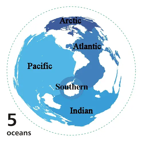
Click or tap the map to enlarge it.
World Ocean Map: Key Takeaways
As a cartographer, the World Ocean Map 5 Oceans provides a comprehensive understanding of Earth’s oceans. It visualizes the distribution and names of the five major oceans: the Atlantic, Pacific, Indian, Southern, and Arctic Oceans. This article explores the history behind the map, provides unique insights, key facts, frequently asked questions, and external resources for further exploration.
History of the World Ocean Map
The World Ocean Map 5 Oceans has a rich history that dates back centuries. Early cartographers and explorers contributed to mapping the oceans, recognizing their magnitude and significance. Over time, advancements in technology and scientific research led to a more accurate representation of the world’s oceans.
Unique Insights
1. Oceans Cover Majority of Earth’s Surface: Approximately 71% of Earth’s surface is covered by oceans. These vast bodies of water play a crucial role in regulating climate, supporting marine life, and impacting weather patterns.
2. Different Depths: The World Ocean Map 5 Oceans showcases varying depths across the oceans. From shallow continental shelves to deep trenches, this map illustrates the diversity of the ocean floor.
3. Ocean Currents: The map demonstrates the major ocean currents, such as the Gulf Stream, the Kuroshio Current, and the Antarctic Circumpolar Current. These currents have a significant influence on global weather patterns and marine ecosystems.
4. Importance of the Southern Ocean: The Southern Ocean, recognized as the fifth ocean on the World Ocean Map, is characterized by its unique ecosystem and important role in regulating global climate.
Table: Relevant Facts
| Ocean | Area (sq km) | Deepest Point (meters) |
|---|---|---|
| Atlantic Ocean | 106,460,000 | 8,376 |
| Pacific Ocean | 168,723,000 | 10,911 |
| Indian Ocean | 70,560,000 | 7,906 |
| Southern Ocean | 20,327,000 | 7,235 |
| Arctic Ocean | 14,056,000 | 5,450 |
Frequently Asked Questions (FAQs)
-
What are the five oceans represented on the World Ocean Map 5 Oceans?
The five oceans represented on the World Ocean Map 5 Oceans are the Atlantic Ocean, Pacific Ocean, Indian Ocean, Southern Ocean, and Arctic Ocean.
-
What is the significance of ocean currents?
Ocean currents play a crucial role in redistributing heat around the globe. They influence climate patterns, weather conditions, and the distribution of marine organisms.
-
Why is the Southern Ocean considered the fifth ocean?
The Southern Ocean is recognized as the fifth ocean due to its unique characteristics and distinct ecosystems. It encircles Antarctica and helps regulate global climate.
-
What is the largest ocean on Earth?
The Pacific Ocean is the largest ocean on Earth, covering approximately 30% of the Earth’s surface.
-
What are the major ocean currents portrayed on the World Ocean Map 5 Oceans?
The major ocean currents portrayed on the World Ocean Map are the Gulf Stream, Kuroshio Current, and the Antarctic Circumpolar Current.
-
How do oceans impact climate?
Oceans play a vital role in regulating global climate by absorbing and releasing heat, storing carbon dioxide, and influencing atmospheric circulation patterns.
-
What is the approximate percentage of Earth’s surface covered by oceans?
Oceans cover approximately 71% of Earth’s surface.